
Jefferson Pier
Jefferson Pier, also called Jefferson Stone or Jefferson Pier Stone, is a granite obelisk in Washington, D.C. It marks the first meridian of the United States, although it was never officially recognized by presidential proclamation or by an act or resolution of Congress. The monument is located 390 feet (119 m) from the center of the Washington Monument. In 1920, Congress approved the placement of a new marker, the Zero Milestone, on the Ellipse to determine official distances from Washington. This new marker, a gift from the Lee Highway Association, was placed one foot west of the original north-south meridian line from the center of the White House.
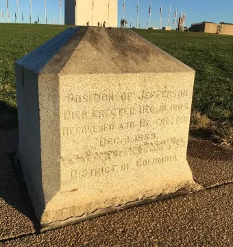
© NPS · Public domain
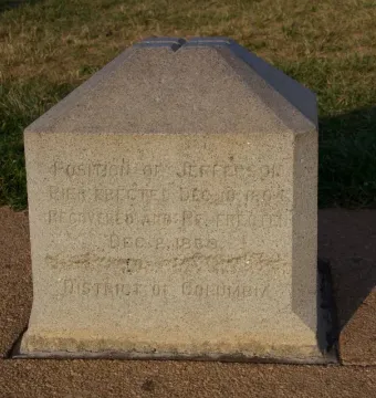
July 2012 © Mike Peel · CC BY-SA 4.0
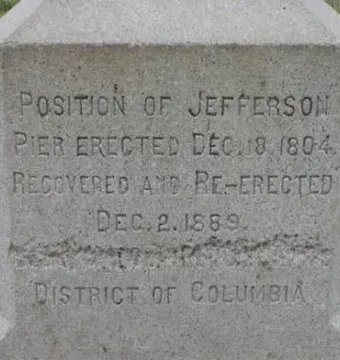
© National Park Service · Public domain
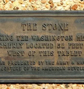
April 2006 © dbking · CC BY 2.0
© User:Eoghanacht · Public domain
Identification | |
| Title | Jefferson Pier |
| Alternative names | Jefferson Stone; Jefferson Pier Stone |
| Type | stone marker; surveying pier; monument |
Location and ownership | |
| Location | Washington, D.C., United States; National Mall, Washington, D.C. |
Historical context | |
| Survey information | Andrew Ellicott measured a prime meridian through the future site of the U.S. Capitol |
| Associated meridian | Washington Meridian, sometimes termed the 16th Street Meridian |
| Original marker name | Jefferson stone pier |
| Named for | Thomas Jefferson |
| Planning note | The planned equestrian statue of George Washington was never constructed as planned; Washington's equestrian statue was not made until 1860 and was ultimately placed elsewhere |
| Related monument type | Future equestrian statue of George Washington |
| Planned location | The west end of the proposed grand avenue at the triangle's southwest corner |
| Historical note | The planned grand avenue later became the portion of the National Mall between the Capitol grounds and the Washington Monument |
| Context of request | Jefferson requested a survey of a meridian through the President's House while living there as President of the United States |
| Earlier survey | Jefferson had previously directed a survey of a different meridian eleven years earlier while serving as Secretary of State |
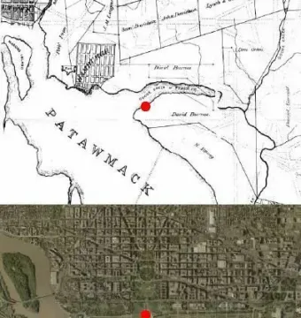
| Earlier site condition | Originally on the south bank of Tiber Creek near its confluence with the Potomac River |
| Site selection rationale | Jefferson wanted the United States to become scientifically as well as politically independent from Europe; the capital was intended to contain a new first meridian |
| Function | Marks the United States' first meridian and the intersection of survey lines from the President's House and the planned Capitol |
| Official recognition | Never officially recognized by presidential proclamation or by an act or resolution of Congress |
| Related people | Pierre Charles L'Enfant; Andrew Ellicott; Thomas Jefferson; George Washington |
| Jefferson's role | As U.S. Secretary of State, he supervised Ellicott's and L'Enfant's activities during the initial planning of the capital |
| Planning context | Chosen in Pierre Charles L'Enfant's 1791 plan for the capital, intended as the permanent seat of the U.S. government |
| Geometric context | The site was part of a large right triangle in L'Enfant's plan, formed by projected lines between the President's House and the Congress House |
| Original site | At the point identified in L'Enfant's plan as the future site of George Washington's equestrian statue |
| Previous marker at site | Replaced one of two wooden posts driven into the ground in 1793 |
| Uncertainty noted | It is not known why Jefferson requested a new meridian survey after the earlier one |
Creator | |
| Erected by | Nicholas King, Surveyor of the City of Washington |
| Surveyed by | Isaac Briggs |
| Commissioned by | Requested by Thomas Jefferson in 1804 |
History and restoration | |
| New marker donor | Lee Highway Association |
| Marker lowered | To within 8 inches of its top, so the inscription was not visible above ground |
| Current maintenance | Maintained today by the National Park Service under its National Mall and Memorial Parks administrative unit |
| Reported location error | Due to errors in the 1804 survey or in a later replacement, the pier's center is now south of the Capitol's centerline |
| Reason this did not happen | Concerns about the bearing capacity of the soil |
| Original intended relation to Washington Monument | The developers of the Washington Monument originally wanted the memorial to be located at the site of the Jefferson Pier |
| Construction context | Served as a benchmark when the Washington Monument's construction began |
| Used as | A mooring post by barges during and after the first phase of the Washington Monument's construction |
| Washington Monument construction began | 1848 |
| New marker placement | Placed one foot west of the original north-south meridian line extending from the center of the White House |
| New marker purpose | A marker from which Washington's official distances, or official mileages from Washington, would be determined |
| Cleanup work | Filled gullies, planted trees, and constructed ornamental ponds and a broad carriage road around the stump |
| Later state | The marker later disappeared from view |
| Replacement marker location | Above the recovered foundation of the original marker |
| Removal circumstances | Removed without recognizing the significance of the stone, during cleanup and grading around the unfinished stump of the Washington Monument |
| New marker location | The Ellipse |
| Marker removal date | 1872–1874 |
| Removed by | United States Army Corps of Engineers |
| Replacement marker erected by | John Stewart, a draftsman acting on the instructions of Colonel O. H. Ernst, Officer in Charge of Public Buildings and Grounds |
| Original marker recovered and re-erected date | December 2, 1889 |
| Original marker date | December 18, 1804 |
| Date erected | October 15, 1804 |
| Post-removal remains | About 20 inches of the stone's foundation was left in place |
| Ground alteration date | 1899 |
| Ground alteration | The ground on the west side of the pier was sloped to show the inscription on the pier |
| Meridian change date | 1850 |
| Meridian change | The meridian of the United States was changed to the center of the small dome of the Old Naval Observatory |
| Legal prime meridian change date | 1912 |
| Legal prime meridian change | Replaced by the Greenwich Meridian as the legal prime meridian for both boundaries and navigation |
| New marker approval date | 1920 |
| New marker | Zero Milestone |
Physical characteristics | |
| Distance from Washington Monument | 390 feet (119 m) |
| Current position | WNW of the center of the Washington Monument; almost due south of the center of the White House and the midline of 16th Street, NW; about due west of the center of the United States Capitol building; almost due north of the center of the Jefferson Memorial |
| Form | Tall monolith; massive pillar, most of its length buried vertically in the ground for stability |
| Current longitude | 77°2'11.56" west of Greenwich (NAD 83) |
Materials | |
| Material | Granite; a small pier covered by a flat free stone |
Technique | |
| Reported west-side inscription | "Position of the meridian post, erected September 20, 1793, and position of the Jefferson stone pier, erected December 18, 1804, and recovered and reerected, December 2, 1889." |
| Inscription accuracy | Silvio Bedini wrote that the 1898 and 1899 reports did not accurately describe the inscription |
| Reported inscription date | 1898 and 1899 reports |
| Inscription or marking | The lines are drawn on the flat free stone |
| Original chiseled-out fifth line | Reportedly once incorrectly stated: "BEING THE CENTRE POINT OF THE" |
| Inscription text | POSITION OF JEFFERSON PIER ERECTED DEC 18, 1804. RECOVERED AND RE-ERECTED DEC 2, 1889. [fifth line chiseled out] DISTRICT OF COLUMBIA |
| Inscription | A defaced inscription engraved on the west face |
| Surface markings | Crossing longitudinal and latitudinal lines engraved on the upper surface |
Significance | |
| Historical comparison | Often overlooked by tourists and sometimes confusing to tourists |
| Related monument | Ellipse Meridian Stone, placed in 1890 by the Coast and Geodetic Survey in the center of the Ellipse in President's Park |
| Relative location of related monument | About north of the Jefferson Pier |
| Placement context of related monument | Located in a more protected area |
| Measurement method | Theodolite measurements |
| Measurement result | The Ellipse Meridian Stone stood off the longitudinal line of the replacement Jefferson Stone |
| Interpretation of measurement | This indicated that one of the two markers was improperly located |
Other | |
| Type of object | Artifact |